Space scouts
The secrets of space will soon be fewer. FFI instruments are already circling Saturn. In 2021, the ground-penetrating radar RIMFAX is investigating the subsurface of Mars. An equally important task is to detect ships hiding in Norwegian waters.
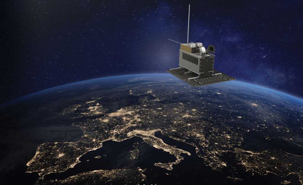
How is it possible to monitor shipping – including vessels that do not want to be monitored? NorSat-3 will be launched in the spring of 2021. This small satellite is equipped with a radar detector. FFI has developed a technology that in principle makes it possible to see and follow all ships with their radar switched on. No one will be able to sail unseen when manoeuvring through the two million square kilometre area of Norwegian territorial waters.
NorSat-3 won’t win any beauty contests. However, it’s what is inside that matters. This satellite is yet another advanced surveillance instrument from a research community that specialises in these.
Norway’s first microsatellite was the AIS-Sat-1. It was launched in 2010, with an Automatic Identification System receiver (AIS) on board. The receiver detects an-ti-collision signals from ships. The aim is to improve safety at sea. In this case, larger ships exchange data regarding position, course and speed.
However, not all vessels are willing to share their movements. Technical issues and deliberate deception may both be involved: AIS transmitters can be turned off. Fortunately, other signals from ships can provide a more complete picture, for instance, the ship’s own radar, which the NorSat-3 can track.
Polar orbit
The overview of shipping in Norwegian waters, around Svalbard and the rest of the Arctic, including the Northeast Passage, is better than it has ever been.
Norwegian microsatellite orbits are unique. They do not circle at the equator, but rather around the North Pole. These pass near the North Pole 15 times a day, at a height of 600 kilometres. Once they are within range of Vardø or Svalbard, new data is downloaded to these stations.
In the 1990s, FFI showed how ships and oil spills could be detected from space. The institute was a driving force for the utilisation of this technology. It was not too difficult to argue in favour of this: One of the first satellite images showed more than 40 foreign trawlers fishing in the ‘Loophole’ in the Barents Sea, close to the borders of Norwegian zones. Even with a hundred coastguard vessels, these would not have had the same monitoring capacity as this little device in space, hundreds of kilometres above fishing poachers and government actors.
These positive experiences with AIS-Sat-1 led to the construction of its twin, the AISSat-2. It was launched on 8 July 2014. A third satellite, the AISSat-3 was lost during a failed launch from Russia in November 2017.
When a satellite is sent up into orbit and is hopefully useful for many years, it is essential that it carries several tools: Nor-Sat-1 has a Swiss solar instrument and Norwegian Langmuir probes for studying the Northern Lights. NorSat-2 is testing VDES – a new international standard for testing two-way communication at sea. Both were launched in the summer of 2017.
Ferdinand initiated Norwegian space age
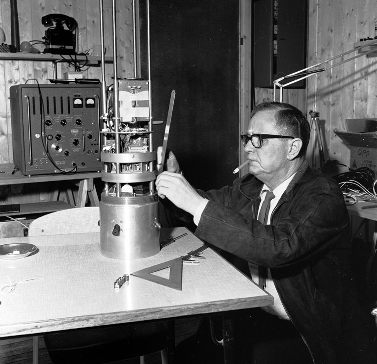
The Norwegian space age began long be-fore. On 18 August 1962, the civil research rocket Ferdinand 1 was launched from Andenes on Andøya. The launch took place from the newly established rocket range at Oksebåsen (Bull Base), hence the name of the rocket. The work on the rocket range began in 1960, just three years after the Soviet Union launched Sputnik. FFI and the Royal Norwegian Council for Scientific and Industrial Research took the initiative jointly.
Andøya still has the northernmost permanent rocket range in the world, on the 69th parallel north. There were many good reasons for choosing this site: The island is located in a zone with the most frequent appearance of Northern Lights. The sea around the island never freezes and provides an enormous catchment area for the rockets.
Researchers can therefore choose many different rocket trajectories. It is also easy for both Norwegian and international research communities to access the site.
From Andøya to Saturn
Ferdinand was part of FFI’s ionosphere research, a field that FFI began studying as early as 1946. The ionosphere is the part of the atmosphere that has electrically charged particles, from 80 kilometres above the planet’s surface.
Over time, the ‘ionosphere’ group changed its name to the more descriptive 'space physics' group. Researchers here were involved in a large share of the well over 100 research rockets that were launched from Oksebåsen. FFI was behind the very first lidar instrument on a rocket. Lidar is an optic, remote sensing method based on lasers.
Gradually, researchers have moved further out into space. FFI researchers were involved in the major Cassini/Huygens Mission. This brought the institute’s work all the way to Saturn.
The dates alone describe the adventure of the Saturn journey. The launch took place in October 1997. In 2004, the probe arrived at the solar system’s sixth and second largest planet. There, it began orbiting the planet, after passing close to Venus, Earth and Jupiter, to increase its speed toward its target. The satellite sends data on the complex magnetosphere around Saturn and its many moons, of which 82 have so far been discovered.
The Huygens probe had a spectacular landing on the moon of Titan, with a video recorded on its descent. Although the FFI group did not have instruments on the Huygens, they were involved in the planning of the probe. This included planning of the instruments on board that would study the waves and turbulence in the atmosphere around Titan.
An electron spectrometer, developed in part by FFI, went along on the journey. This was built on another instrument that was developed into the ESA Cluster mission: Four satellites in coordinated orbits that studied the interactions between the solar wind and the Earth’s magnetosphere. This included a device that allowed researchers to experiment with unwanted electrical charges of the spacecraft. This improved measurements by the electron spectrometer and other plasma instruments.
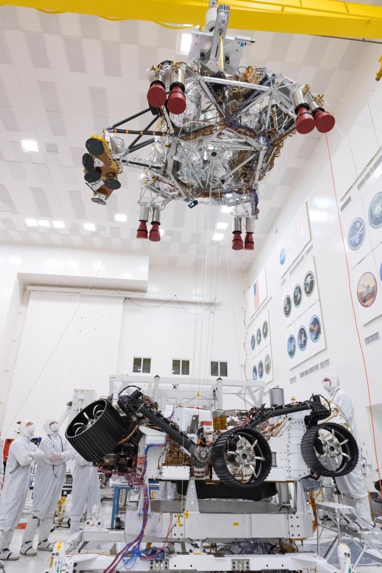
Is there life on Mars? sings David Bowie. RIMFAX may help answer that question.

Bowie sings, RIMFAX searches
FFI’s list of space projects and partners grows longer each year. At the top of the list during the 2021 anniversary year is the ground-penetrating radar, RIMFAX. The name stands for Radar Imager for Mars' Subsurface Experiment. It is also a word play on Norse mythology: Rimfakse is the horse that the night rides across the sky.
Morning dew is what drips from Rimfakse’s bit. The name can be translated as "frost from the muzzle". "The bestselling show: Is there life on Mars?" sings David Bowie. RIMFAX may help answer that question. The antenna and the anonymous, gold-plated box is one of seven instruments mounted on NASA’s Mars rover, Perseverance.
The rover landed in February 2021, after a journey that began in summer 2020. As soon as the instruments were ready, RIMFAX began sending data – not from Earth, but from Mars. Earlier studies of the planet have identified minerals that can only be formed in water. An important goal is to find sedimentary layers that might have supported past life.
RIMFAX enables researchers to get an idea of the basic conditions of the ground under the rover. This will provide important information on areas of interest for further study.
RIMFAX is a Ground Penetrating Radar (GPR). It takes pictures of Mars geology several metres below the surface. This is done by sending electromagnetic radio waves. The radar then reads the reflected signals. GPR is often used on our own planet in order to study layers of soil and ice and to locate groundwater.
FFI developed ground-penetrating radars of this type to enable the Norwegian Armed Forces to ‘see’ through walls and beneath the ground. Areas of use include the detection of buried mines. The same type of technology is used in archaeology, and to study avalanches. FFI has also studied the use of this type of ultra-broadband radars for medical purposes, for instance, in providing images of the heart.
Broad collaboration, new questions
RIMFAX is typical of FFI’s work on space research, as it is a broad-reaching project: FFI has collaborated with the Norwegian Space Agency, Kongsberg Norspace AS, Bitvis AS and Comrod AS on the construction of this instrument.
FFI has made many visits to space since 1962. The institute has many more invitations. This results in fewer secrets, while research also leads to new and bigger questions.